This is the former Williams Air Force Base, which closed about 20 years ago. It is now Phoenix-Mesa Williams Gateway Airport.
There are some commercial passenger flights at this airport, but mostly it is used as a business park for companies that want to be located at a facility that includes several large runways.
When I was a child, we frequently heard the jets and sonic booms from the Air Force operations at what was known as "Willy."
Today is Sunday, so we have new photos posted on our Viva la Voyage travel photo site. This week we are showing photos of Croatia. The Dalmatian Coast of Croatia is a scenic, cultural and architecturally intriguing place to visit.
Showing posts with label Aerial Photos. Show all posts
Sunday, August 3, 2014
Thursday, July 31, 2014
Aerial Photo: Desert Agriculture and Housing
This photo shows circular shapes of irrigated crops in the desert, and circular shapes of the houses, streets, and even the golf courses in Sun Lakes in the southeast valley.
This week we have photos of the people of Guatemala posted on our Viva la Voyage travel photo site.
Wednesday, July 30, 2014
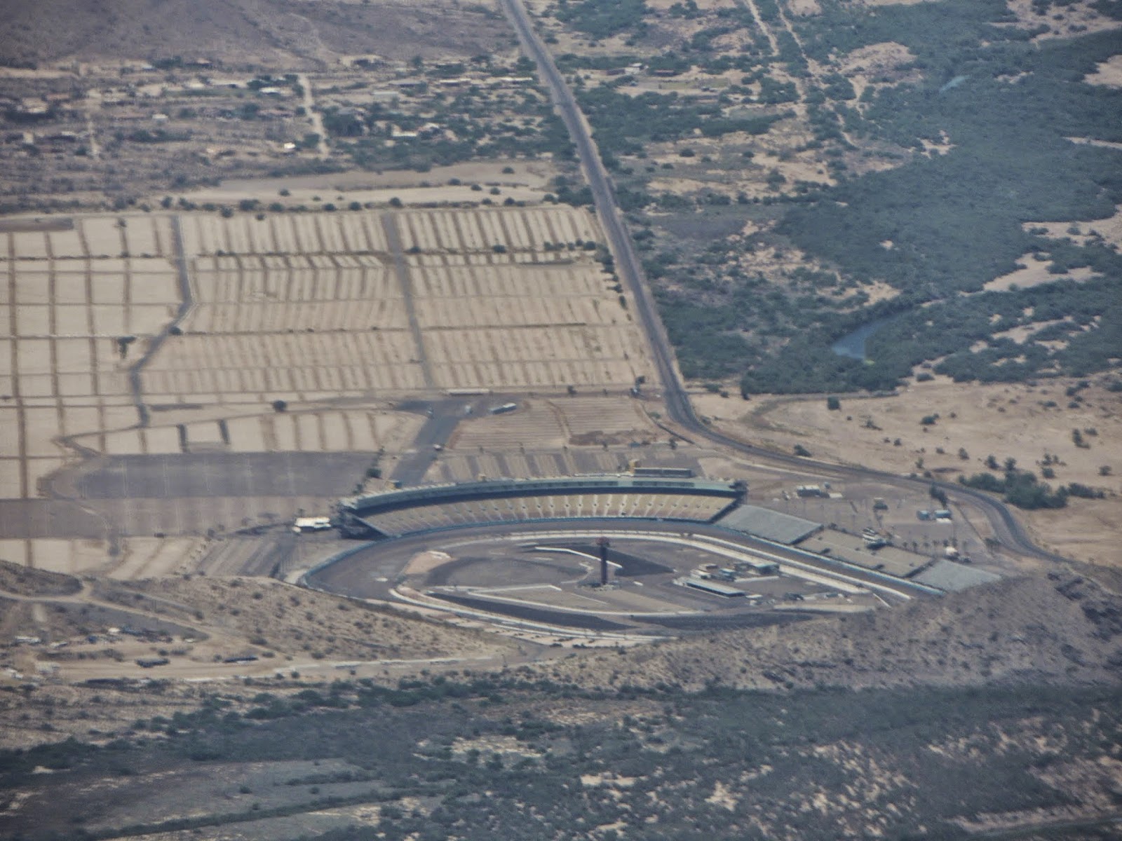
Aerial Photo: Phoenix International Raceway
While flying out of Phoenix, we flew near Phoenix International Raceway just west of town. They hold Nascar races here
The most unusual aspect of this photo is that there is a bit of water in the Salt River above and to the right of the race track. Water is released from the dams and flows in the river only once every few years.
This week we have photos of the people of Guatemala posted on our Viva la Voyage travel photo site.
The most unusual aspect of this photo is that there is a bit of water in the Salt River above and to the right of the race track. Water is released from the dams and flows in the river only once every few years.
This week we have photos of the people of Guatemala posted on our Viva la Voyage travel photo site.
Tuesday, July 29, 2014
Aerial Photo: The Arizona State Capitol
This is the Arizona State Capitol complex. The original Capitol is under the low copper dome. The Senate and House of Representative buildings were added to the right, in front of the Capitol. Behind the Capitol on the left is a 9-story tower that houses executive branch agencies, with the Governor's Office on the 9th floor.
My husband complains about how the buildings with "mid-20th century charm, or lack thereof" dwarf the old, historic Capitol building.dow
This week we have photos of the people of Guatemala posted on our Viva la Voyage travel photo site.
My husband complains about how the buildings with "mid-20th century charm, or lack thereof" dwarf the old, historic Capitol building.dow
This week we have photos of the people of Guatemala posted on our Viva la Voyage travel photo site.
Monday, July 28, 2014
Photo: Aerial Photo of Downtown Phoenix
This is a wider view than yesterday's photo of the ball park. This shows most of downtown Phoenix.
This week we have photos of the people of Guatemala posted on our Viva la Voyage travel photo site.
Labels:
Aerial Photos,
Downtown Phoenix
Sunday, July 27, 2014
Aerial Photo: Chase Field
The roof is usually open at Chase Field in downtown Phoenix except when they are getting ready for or playing a game during the summer heat.
Today is Sunday, so we have new photos posted on our Viva la Voyage travel photo site. This week we are featuring the people of Guatemala.
Labels:
Aerial Photos,
Chase Field,
Downtown Phoenix
Friday, July 11, 2014
Photo: Recipe for Arizona Agriculture -- Just Add Water
This aerial view of the Arizona desert shows that in those locations where water is applied, the desert soil is fertile and supports agriculture. Some farms use lasers to level the ground to reduce water runoff.
This farm has a section of what is likely the Central Arizona Project canal slicing across it. The C.A.P. carries water from the Colorado RIver about 300 miles across the desert to Phoenix and aerTucson.
This week on our Viva la Voyage travel photo site we are showing some underwater photos from the Sea of Cortez, including several photos of sea lions swimming underwater with us.
This farm has a section of what is likely the Central Arizona Project canal slicing across it. The C.A.P. carries water from the Colorado RIver about 300 miles across the desert to Phoenix and aerTucson.
This week on our Viva la Voyage travel photo site we are showing some underwater photos from the Sea of Cortez, including several photos of sea lions swimming underwater with us.
Thursday, July 10, 2014
Photo: An Open Pit Mine
Continuing my series of aerial photos after a take off from Phoenix Sky Harbor Airport, here is an open pit mine in the desert east of Phoenix.
Copper is one of the "5 C's" that we were taught in school that historically have been the foundation of Arizona's economy -- cattle, copper, cotton, citrus and climate. Copper mining remains important today.
This week on our Viva la Voyage travel photo site we are showing some underwater photos from the Sea of Cortez, including several photos of sea lions swimming underwater with us.
Copper is one of the "5 C's" that we were taught in school that historically have been the foundation of Arizona's economy -- cattle, copper, cotton, citrus and climate. Copper mining remains important today.
This week on our Viva la Voyage travel photo site we are showing some underwater photos from the Sea of Cortez, including several photos of sea lions swimming underwater with us.
Wednesday, July 9, 2014
Photo: Wind farm
As our airliner climbed out of the Phoenix area, we noticed this facility int he desert with rows and rows of windmills.
It seems like a good place for a lot of windmills, which a appear to be part of the overall solution to our dependence on fossil fuels.
This week on our Viva la Voyage travel photo site we are showing some underwater photos from the Sea of Cortez, including several photos of sea lions swimming underwater with us.
It seems like a good place for a lot of windmills, which a appear to be part of the overall solution to our dependence on fossil fuels.
This week on our Viva la Voyage travel photo site we are showing some underwater photos from the Sea of Cortez, including several photos of sea lions swimming underwater with us.
Tuesday, July 8, 2014
Photo: Tribal Lands Bordering Scottsdale
This photo shows the difference in land use between urban Scottsdale, on the left, and the agricultural lands of the Salt River Pima Maricopa Indian Community that borders central Scottsdale on the east.
The border between Scottsdale and the tribal lands (I do not use the R-word, as it does not show proper respect for Native Americans) is Pima Road, just to the left of the 101 Freeway.
Back in the 1980's the Native American community was justifiably upset that the City had knows for a long time that there were plans to build a freeway, but the City allowed houses to be built right up next to Pima Road so that it would be too expensive to clear the right of way if Pima Road was the location for the freeway. The tribal leaders resented that the City just assumed that tribal lands would be take for the freeway.
So, the lease for Pima Road the use of tribal lands for the northbound lane of Pima Road expired and the tribe refused to renew the lease. Half of the road had to be closed.
The tribe then got an acceptable deal for their lands that were used for the freeway, and the have since developed significant revenue sources with the enhanced land values due to proximity to the freeway. There are several shopping centers, office buildings, the Spring training facilities and stadium for the Arizona Diamondbacks and Colorado Rockies, and more.
And of course none of the sales tax revenue from those facilities goes to Scottsdale because the facilities are located on tribal lands, outside the city limits.
This week on our Viva la Voyage travel photo site we are showing some underwater photos from the Sea of Cortez, including several photos of sea lions swimming underwater with us.
The border between Scottsdale and the tribal lands (I do not use the R-word, as it does not show proper respect for Native Americans) is Pima Road, just to the left of the 101 Freeway.
Back in the 1980's the Native American community was justifiably upset that the City had knows for a long time that there were plans to build a freeway, but the City allowed houses to be built right up next to Pima Road so that it would be too expensive to clear the right of way if Pima Road was the location for the freeway. The tribal leaders resented that the City just assumed that tribal lands would be take for the freeway.
So, the lease for Pima Road the use of tribal lands for the northbound lane of Pima Road expired and the tribe refused to renew the lease. Half of the road had to be closed.
The tribe then got an acceptable deal for their lands that were used for the freeway, and the have since developed significant revenue sources with the enhanced land values due to proximity to the freeway. There are several shopping centers, office buildings, the Spring training facilities and stadium for the Arizona Diamondbacks and Colorado Rockies, and more.
And of course none of the sales tax revenue from those facilities goes to Scottsdale because the facilities are located on tribal lands, outside the city limits.
This week on our Viva la Voyage travel photo site we are showing some underwater photos from the Sea of Cortez, including several photos of sea lions swimming underwater with us.
Monday, July 7, 2014
Photo: Central Scottsdale from the air
Continuing with this little series of photos from our airliner as it left Phoenix's Sky Harbor airport heading east, this is a photo of central Scottsdale, looking north. Here are some of the things you can see.
In the lower right is Sky Song, the research park owned by Arizona State University. Extending west is the stretch of McDowell Road known as the "motor mile" because of the many car dealerships, which are the larger buildings across the lower middle of this photo. Many of them are now closed, victims of the recession, consolidation of auto brands, and large newer dealerships in north Scottsdale.
At the far left edge are the baseball fields where the Oakland A's do their Spring Training. That is also the side of a former prisoner of war camp for Germans during World War II. At the center right is downtown Scottsdale, usually called Old Town. "Old" in Scottsdale means 1950's and 60's. Scottsdale Fashion Square and the Waterfront is just north of downtown.
Camelback Mountain is still prominent in this view, and the Phoenecian Resort is visible near the right base of Camelback. Beyond Camelback is Mummy Mountain, and the area between Camelback and Mummy Mountains is the heart of Paradise Valley.
Today is Sunday, so we have new photos posted on our Viva la Voyage travel photo site. This week we are showing some underwater photos from the Sea of Cortez, including several photos of sea lions swimming underwater with us.
In the lower right is Sky Song, the research park owned by Arizona State University. Extending west is the stretch of McDowell Road known as the "motor mile" because of the many car dealerships, which are the larger buildings across the lower middle of this photo. Many of them are now closed, victims of the recession, consolidation of auto brands, and large newer dealerships in north Scottsdale.
At the far left edge are the baseball fields where the Oakland A's do their Spring Training. That is also the side of a former prisoner of war camp for Germans during World War II. At the center right is downtown Scottsdale, usually called Old Town. "Old" in Scottsdale means 1950's and 60's. Scottsdale Fashion Square and the Waterfront is just north of downtown.
Camelback Mountain is still prominent in this view, and the Phoenecian Resort is visible near the right base of Camelback. Beyond Camelback is Mummy Mountain, and the area between Camelback and Mummy Mountains is the heart of Paradise Valley.
Today is Sunday, so we have new photos posted on our Viva la Voyage travel photo site. This week we are showing some underwater photos from the Sea of Cortez, including several photos of sea lions swimming underwater with us.
Labels:
Aerial Photos,
Camelback Mountain
Sunday, July 6, 2014
Photo: Desert Botanical Garden from the air
I have posted a lot of photos over the years from the Desert Botanical Garden, as has Sharon on her Phoenix Daily Photo site. Here is a different perspective on the DBG.
In the center of this photo is a butte. The Desert Botanical Garden is on the far slope of that butte. You can see a slightly more green area and a band of buildings. The buildings are the entrance, area, gift shop, restaurant, a classroom building, a multi purpose room where special events are held.
One of the Salt River Project canals slices through the right side of the photo.
Today is Sunday, so we have new photos posted on our Viva la Voyage travel photo site. This week we are showing some underwater photos from the Sea of Cortez, including several photos of sea lions swimming underwater with us.
In the center of this photo is a butte. The Desert Botanical Garden is on the far slope of that butte. You can see a slightly more green area and a band of buildings. The buildings are the entrance, area, gift shop, restaurant, a classroom building, a multi purpose room where special events are held.
One of the Salt River Project canals slices through the right side of the photo.
Today is Sunday, so we have new photos posted on our Viva la Voyage travel photo site. This week we are showing some underwater photos from the Sea of Cortez, including several photos of sea lions swimming underwater with us.
Labels:
Aerial Photos,
Desert Botanical Gardens
Saturday, July 5, 2014
Photo: Camelback Mountain and Papago Park
This is a somewhat different angle than yesterday's post for Camelback Mountain. This is a view from almost due south, with Papago Park in the foreground, just north of some office buildings that include the headquarters for the Salt River Project.
The Papago golf course and Papago Buttes are visible. The Phoenix Zoo is on the lower left of the park.
This week we have photos of Majorca posted on our Viva la Voyage travel photo site.
The Papago golf course and Papago Buttes are visible. The Phoenix Zoo is on the lower left of the park.
This week we have photos of Majorca posted on our Viva la Voyage travel photo site.
Labels:
Aerial Photos,
Camelback Mountain
Friday, July 4, 2014
Photo: Camelback Mountain from the Air
This is a photo of Camelback Mountain from the window of an airliner just after it took off from Phoenix's Sky Harbor Airport. I'll have to try this again on a clear sunny day.
The large white building in the center of the photo is the former Motorola plant, which is now home to ON Semiconductor.
I hope all of my readers in the USA will enjoy today's Independence Day holiday.
This week we have photos of Majorica posted on our Viva la Voyage travel photo site.
The large white building in the center of the photo is the former Motorola plant, which is now home to ON Semiconductor.
I hope all of my readers in the USA will enjoy today's Independence Day holiday.
This week we have photos of Majorica posted on our Viva la Voyage travel photo site.
Labels:
Aerial Photos,
Camelback Mountain
Subscribe to:
Posts (Atom)


